General Information
Topography
The Semo Port area is included in the landform identified as the Mississippi River bottom land. The area consists of flood plains. Elevations decrease from east to west and range from 450 feet along the Mississippi River to 335 feet in the area adjacent to Interstate 55. Semo Port’s property includes diverse formations including bottomlands, terraces, and ridgetops. Land use in the area is predominantly agricultural, with several industrial areas, a regional airport, and three rock quarries nearby.
Water Resources
Major water resources in the area include the Mississippi River, Headwater Diversion Channel, Ramsey Creek Diversion Channel, Marquette Lakes, and Cape LaCroix Creek. With the exception of the Mississippi River, each of these was man-made.
Headwater Diversion Channel.
The Headwater Diversion Channel flows from west to east and drains into the Mississippi River at Cape Bend, upstream (northwest) of the Port. It was built between 1910 and 1916 by the Little River Drainage District. By diverting water from rivers and streams as they came from the Ozark foothills, and taking the water directly eastward to the Mississippi River, the channel served as a key element in the drainage of Missouri’s Bootheel region. Construction of the channel allowed a vast region to be cleared and converted to agriculture, creating some of the nation’s most productive farmland. Today, the Headwater Diversion Channel serves parts of seven counties and has a total drainage area of approximately 1,200 square miles.
Ramsey Creek Diversion Channel.
The Ramsey Creek Diversion Channel is located south of the Headwater Diversion Channel. It flows eastward along the base of the hills southwest of Scott City, then follows a channelized course along the levee eastward and northward, past the northwest edge of Scott City, and into the Headwater Diversion Channel. It joins the latter at a point between Interstate 55 and the Semo Port Railroad bridge. It was built between 1910 and 1916 as part of the Little River Drainage District’s land reclamation project.
The material excavated from the two diversion channels served as the original flood levees. After the 1927 flood, Congress initiated a project known as the Mississippi River and Tributaries Project under the supervision of the U. S. Army’s Corps of Engineers. The MRT Project authorized the Corps to raise, strengthen, and improve levees along the mainline of the Mississippi River to pass a 500-year flood elevation. Additional work was performed in the mid-1960’s on the local levees. The levees along the Headwater Diversion Channel and the Ramsey Creek Diversion Channel protect most of the Missouri Bootheel and northeastern Arkansas from flooding. Without the levees, during great floods the Mississippi River would return to its ancient channel (to the southwest) and flow across the Missouri Bootheel and eastern Arkansas to the area around Helena, Arkansas, causing extensive damage and destruction.
Marquette Lakes.
The Marquette Lakes were built by Marquette Cement Company, which operated a cement plant in Cape Girardeau (it is now part of Lone Star Industries). There are two lakes, one north of the Headwater Diversion Channel and one south.
The Marquette Lakes were originally a series of clay pits where steam shovels dug clay which was hauled by trains to the cement plant, about two miles north. The process continued for several decades, from the early 1900’s to 1950’s. As a historical note, two of the old steam locomotives used by Marquette Cement for the clay trains are on display in Cape Girardeau’s Arena Park and Capaha Park (with saddle tanks removed). Today the Marquette Lakes are used for recreational purposes (fishing, boating, camping, picnics).
Cape LaCroix Creek and Diversion Channel. Cape LaCroix Creek empties into the Mississippi River in an industrial area of south Cape Girardeau, adjacent to the City of Cape Girardeau’s municipal sewage treatment plant. The original creek meandered through lowlands alongside the river from Cape Girardeau southward to the present location of Semo Port’s harbor. The Cape LaCroix Creek Diversion Channel in south Cape provided a direct flow into the river, allowing industry to develop in south Cape Girardeau (along Sprigg Street, railroads, and the river). Farther south, the Headwater Diversion Channel and its north ditch also cut the old creek bed. The remains of the old creek bed are now a shallow ditch and some wetlands areas, filled with silt from successive river floods.
Geology
The majority of the area lies in the Advance Lowland, a part of the Coastal Plain Physiographic Province, and an ancient channel of the Mississippi River. The Advanced Lowland is composed of 100 to 150 feet of Ice Age sand and gravel, materials derived from adjacent bluffs, and Mississippi River sediments.
The underlying bedrock units consist of Ordovician sandstones, dolomites, and limestones. Overlying the bedrock are Cretaceous sands and gravels, sediments derived from the Mississippi River and adjacent uplands, and relatively compact loess deposits.
Limestone deposits have proven valuable for the production of crushed stone and cement. Three rock quarries operate within a few miles of the Port, and several abandoned quarries are in the area.
Soils
Soils in the project area belong to the Sharkey Association. This soil association consists of former channels of the Mississippi and Ohio Rivers. These soils are poorly drained, and are sticky when wet and crack when dry. Sharkey soils are typically found in the lowest part of the area. The surface layer is usually very dark grayish brown silty clay approximately 7 inches thick. The subsoil is about 47 inches thick and is gray, mottled firm clay. The substratum consists of gray, mottled, firm silty clay to a depth of 72 inches.
These soils have fair to good potential for cultivated crops if properly drained. Land grading is commonly used to provide uniform drainage. Most of the project area is made up of Sharkey silty clay soil (No. 58), which is usually found on broad flats or in concave depressions. It is protected by levees but may flood if runoff is received from adjacent areas. Surface runoff is slow, natural fertility is high, permeability is very slow.
Also included are areas of Memphis silt loam, 5 to 9 percent slopes, (No. 52C) and Memphis silt load, 14 to 40 percent slopes, (No. 52E3), severely eroded. Both of these soils are well drained and can be found on side slopes and ridgetops of the uplands. Individual areas of this soil are long and narrow. Most areas of these soils are used for pasture, cropland, and orchards. It has good potential for hay, pasture, orchards, and trees; however, it is considered unsatisfactory for most sanitary facilities and as building sites.
In the area south of Marquette Lakes and east to the Mississippi River is Adler silt loam (No. 31). This soil is usually found on flood plains and along drainageways in the uplands. This soil has moderate permeability, surface runoff is slow, and the available water capacity is very high. During the winter and spring this soil has a high water table within 2 or 3 feet of the surface.
Soils along the Ramsey Creek Diversion Channel consist of Orthents-Water complex (No. 67). This soil type makes up the levee that parallels the Mississippi River and the Headwater Diversion Channel and its levee system. Areas of this soil are characterized by long, narrow bands of loamy and clayey soils. It consists of materials ranging in texture from sand to clay that were dug from ditches and borrow pits.
Vegetation
Most areas of the Sharkey soil association are used for the production of soybeans, and smaller portions for the raising of rice, wheat, and corn. A few undrained areas are in pasture or remain in timber. These soils have fair to good potential for cultivated crops if properly drained.
Cultural Resources
As part of the development of Semo Port, several extensive cultural resource studies (archeological, historical properties) have been performed. These include studies by Price (1981), Pauketat (Corps of Engineers, 1983), Wilkie (1985), and Walters (1992).
The Walters study was conducted in early 1992 as part of the Environmental Assessment for the extension of Missouri Route AB from I-55 to Semo Port. Eighteen sites (campsites or residence/farmsteads) were identified in or near the highway construction area. Phase I testing found twelve sites to be not eligible for National Register of Historic Places criteria. Phase II testing at six sites found only one to be eligible (23ST226, a Late Woodland campsite). Due to its relatively small size and primarily lithic, prehistoric artifact assemblage, it was determined appropriate for burial. A Memorandum of Agreement was executed between the Federal Highway Administration, the Advisory Council on Historic Preservation, the Missouri State Historic Preservation Officer, and the Southeast Missouri Regional Port Authority, and Route AB was constructed to bury the site for future research.
Wildlife Resources
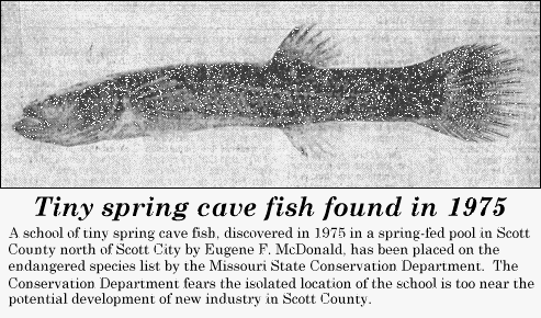
Spring Cavefish. The Spring Cavefish (Chologaster agassizi) is known to inhabit two small sites in Scott County, Missouri, about two miles northeast of Scott City. Their presence was first reported by Pflieger (1975) and later by McDonald and Pflieger (1979). Both sites are on property owned by John Pobst, a local farmer. They are approximately 3400 feet south of the confluence of the Headwater Diversion Channel and the Mississippi River, at the base of a bluff line approximately 3,000 feet west of the harbor.
The two sites are a small spring and a spring-fed pool. The small spring (northeast site) flows from an inaccessible cave into a drainage ditch that empties into the old channel of Cape LaCroix Creek (NW 1/4, NW 1/4, Sec 28, T30N, R14E). About 1,500 feet westward is the spring-fed pool (southwest site, SE 1/4, NE 1/4, Sec 29, T30N, R14E).
The spring cavefish is known from only a few localities in Missouri, Illinois, Kentucky, and Tennesses. In 1980 the species was designated by Missouri as a state endangered species, since the sites mentioned above represent the only known occurrence of the species west of the Mississippi River (click here for detailed information).
Indiana Bat. The area is included in the range of habitat of a state and federal endangered mammal, Myotis sodalis, the Indiana Bat. Its habitat includes caves, mines, small stream corridors with well-developed riparian woods, and upland forests. Some limestone caves and man-made caverns of southern and eastern Missouri serve as hibernation sites for a major portion of the world’s total population of this species. Indiana Bats are very vulnerable to human disturbances. Arousal during hibernation exhausts nonreplaceable energy reserves and can seriously impair survival and/or reproduction. Research found that there were no caves within the Semo Port area inhabited by Indiana bats. [Information is from the “Final Environmental Assessment: Nash Road Extension” prepared by Kathy Mangels of the Southeast Missouri Regional Planning and Economic Development Commission, June 1994; and from USF&W.]
Bald Eagle. The bald eagle (Haliaeetus leucocephalus), a federal endangered species, breeds and winters along large rivers and reservoirs. While it utilizes areas upstream and downstream of the Port, it is not known to occur in the immediate Port area. A biological assessment was performed prior to construction of the port, and it was determined that there would be no significant effect on the species. Bald eagles have been observed on Marquette Island.
Least Tern. The least tern (Sterna antillarum), a federal endangered species, is not known to occur in the vicinity of Semo Port. Its habitat is bare alluvial and dredge spoil islands.
Pallid Sturgeon.
The pallid sturgeon (Scaphirhynchus albus), a federal endangered species, occurs in the Mississippi River in areas near Semo Port. The species is thought to spawn over substrates of rock, rubble, or gravel in the main channel of the Mississippi River or on wing dams. The immediate area of the Port’s facilities has been determined not to be habitat for this species.
Mussels.
“Suitable mussel habitats do not exist, nor have any historical mussel beds been identified adjacent to the proposed project site.” (comment from the Missouri Department of Conservation regarding the grain elevator loadout, made after examining the area).
© Copyright 2024, Southeast Missouri Regional Port Authority. All rights reserved.